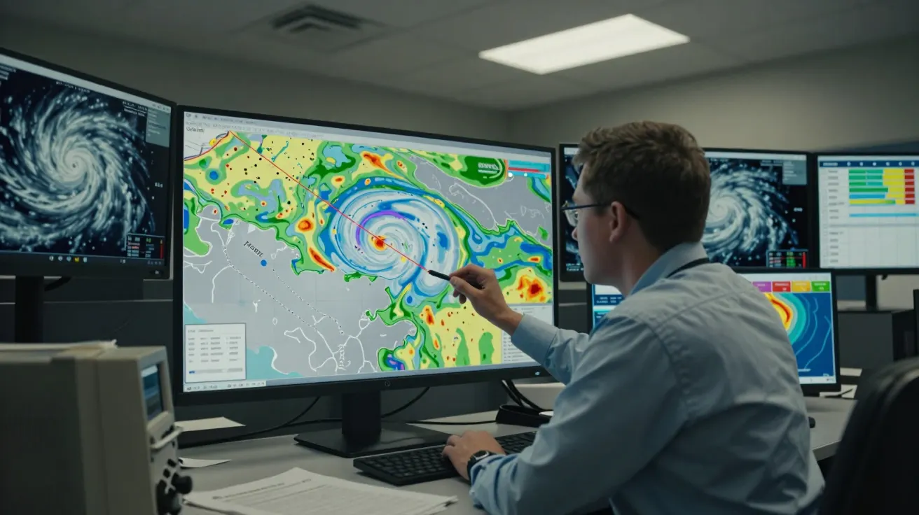
On a grey Tuesday afternoon, the forecast office is quiet in that way it only is before something big. The first model run has just dropped, bands of rain spinning like a Catherine wheel over the Atlantic, pressure lines tightening as the system barrels towards Ireland and the western English Channel. On one screen, a forecaster traces a tiny hook on the southern flank of the storm, squints, zooms in, and mutters the phrase that makes everyone look twice: “Possible sting‑jet set‑up along here.”
Most of us only meet the term later, in a push notification or a late‑night news crawl: “Met Office watching for rare ‘sting jet’ as storm strengthens.” It sounds cinematic, more superhero move than scientific label. But on the ground it translates into something brutally simple - wind that arrives faster, stronger and in a narrower swathe than the public forecast map might suggest at first glance.
A sting jet is not a new type of storm, and it’s not a guaranteed disaster. It’s a particular wind pattern inside some powerful Atlantic lows that can turn what looks like “just another windy night” into hours of damaging gales over a few unlucky counties. Your friend ten miles away posts a calm garden on social media, while your street loses fences, tiles and half a trampoline.
You don’t need to decode satellite charts to live with this. But it helps to understand what forecasters see when they talk about a sting jet, why the Met Office only mentions it rarely, and what it should change about how you read that next amber warning for wind.
What a sting jet actually is (and what it isn’t)
In a textbook mid‑latitude storm, the strongest winds usually wrap around the centre and stay mainly out at sea. The bands of rain sweep through, gusts ramp up and then ease as the low moves away. A sting jet tweaks that script.
Meteorologists use the term for a narrow, fast‑moving core of winds that descends from mid‑levels of the atmosphere on the southern side of a deepening storm. On satellite pictures, that part of the cloud shield often curls into a scorpion‑like tail - the “sting” at the end of the storm’s cloud spiral.
Up there, several kilometres above the surface, the air can be racing far faster than the gusts we normally feel at ground level. Under the right conditions, a ribbon of that high‑momentum air drops down towards the surface, drying out and accelerating as it goes. When it reaches roof height, you get a short, violent burst of gusts in a corridor as little as 30–80 km wide.
It isn’t:
- A hurricane.
- A separate named storm.
- Something that only appears in freak one‑off events.
It is a behaviour inside some powerful Atlantic storms - including a few that have already brushed or hammered the UK in recent decades.
Why forecasters get twitchy when they see the “tail”
From a forecast desk, the ingredients for a sting jet look like a checklist slowly ticking to green. A rapidly deepening low racing in from the Atlantic. Very strong winds a few kilometres up. A sharp contrast between the cold, dry slot sweeping in behind the front and the milder, moister air ahead. A tell‑tale hooked cloud shield on satellite imagery.
Individually, none of those mean disaster. Together, they tell a story:
- The storm is intensifying quickly, so conditions on the ground may change faster than a standard forecast suggests.
- There is a realistic chance of localised gusts much higher than the broad‑brush forecast values, especially near the southern or south‑western flank of the low.
- Standard “gradient wind” expectations (the neat rings of stronger winds around the centre) may be trumped locally by this narrow, plunging jet.
A Met Office meteorologist might put it more quietly on an internal briefing:
“This is still one storm, but parts of its southern wing may behave as if they’re getting a much more severe event.”
That’s why you’ll sometimes see public wording like “damaging gusts in a narrow corridor” or “small changes in the storm track could significantly alter impacts”, even if the word “sting jet” doesn’t make the public forecast.
How the Met Office spots a possible sting jet
Nobody presses a big red STING JET button. Instead, several tools are weighed together, and the level of confidence is constantly updated.
Forecasters tend to look for:
- Model signals of a “dry slot” cutting into the storm: a comma‑shaped clearance on satellite and a tongue of very dry air in model humidity charts.
- Very strong winds at 1–3 km altitude that could be dragged down in showers or downdraughts.
- Rapid pressure falls and tight pressure gradients on the southern side of the low.
- Fine‑scale model runs (down to a few kilometres) hinting at streaks of extreme gusts, not just broad windy areas.
If several models agree, confidence that a sting‑jet‑like feature could develop goes up. If the signal jumps around with each run, caution takes over. That’s one reason the Met Office talks more about impacts than about the label itself.
Behind the scenes, the presence of a possible sting jet can:
- Justify upgrading a warning (for example, from yellow to amber).
- Shift emphasis within a region - highlighting a narrower strip of higher risk.
- Trigger extra coordination calls with emergency planners and infrastructure operators.
Ordinary windy day or sting‑jet set‑up: what changes for you?
From a householder’s point of view, the physics is interesting, but the question is practical: does “sting jet possible” mean you actually need to behave differently?
In most cases, it changes three things:
- How seriously to take that warning colour. An amber wind warning that mentions the risk of “a narrow swathe of very strong gusts” deserves to be treated more like the upper end of amber, shading towards red, for those in the highlighted strip.
- How local the damage might be. You may see intense impacts over a small area - one town with widespread trees down while neighbouring areas report “just a windy evening”.
- How fast conditions can deteriorate. The worst gusts can arrive within an hour or two, with limited gradual build‑up.
Think in terms of low‑probability, high‑impact. Many people under the broader warning area will simply get a rough night. A smaller number, if the sting jet really bites and passes overhead, may face gusts strong enough to fell mature trees, rip off tiles and close bridges.
Reading the warnings: the phrases to watch for
You don’t need to see the words “sting jet” to know forecasters are worried about that flavour of wind event. Listen or look for:
- “A small chance of very strong and damaging gusts in a narrow corridor.”
- “Some places may see gusts significantly higher than the general forecast values.”
- “A very tight gradient on the southern flank of the low, with scope for squally line convection” (in technical blogs or meteorological discussions).
- Emphasis on sudden onset and localised but severe impacts, even where overall storm strength is described as “typical for the time of year”.
When that sort of language appears alongside amber (or especially red) wind warnings, it’s a clue that forecasters are thinking about sting‑jet‑type behaviour, whether or not they spell it out.
What to do if you’re in the higher‑risk strip
Treat this less as an exotic label and more as a nudge to adopt your “proper storm” routine, even if the map only shows amber.
A few low‑fuss steps help most:
- Secure the loose stuff. Bins, trampolines, garden furniture, temporary signage - anything light enough to move in a 70–80 mph gust.
- Avoid non‑essential travel during the peak. If you must drive, expect debris, sudden gusts on exposed bridges and possible closures.
- Keep away from trees and sea fronts. Sting‑jet‑type gusts are particularly efficient at bringing down weak limbs and throwing spray and shingle inland.
- Charge devices and have torches handy. Localised, tree‑related power cuts are common where the sting passes.
- Follow live updates. The precise corridor of strongest winds can shift 30–50 miles as new data comes in.
Think of it this way: you may “over‑prepare” nine times out of ten. The tenth time pays for the rest.
How a sting jet compares with a “normal” windy storm
| Feature | Normal strong autumn/winter storm | Storm with sting‑jet‑type behaviour |
|---|---|---|
| Wind area | Broad region of gales | Narrow corridor of extreme gusts |
| Onset | Gradual build‑up, then peak | Faster ramp‑up over 1–2 hours |
| Damage pattern | Fairly even across a region | Intense strip of damage, calmer either side |
The same named storm can show both behaviours at once: ordinary gales for most, sting‑jet‑style extremes for a smaller slice.
Living with rare but punchy wind events
For UK meteorologists, a sting jet is a reminder that the Atlantic still has surprises to spring, even in an era of supercomputers and dense observation networks. For the rest of us, it’s a reminder that how the wind arrives can matter as much as how strong it is on a neat forecast graphic.
The label will come and go in headlines. What matters is the habit it encourages: reading beyond the colour on the warning map, noticing the hints about “narrow swathes” and “significantly higher gusts”, and adjusting plans on the small number of days when the pattern lines up.
You don’t need to fear every windy chart. You just need a simple, repeatable plan for the handful of times forecasters quietly say: this one could sting.
FAQ:
- Do sting jets only occur in the UK? No. They can form in similar types of Atlantic and European storms wherever the right structure and temperature contrasts occur, but the UK and nearby seas often sit in the firing line for these deepening lows.
- Can forecasters predict a sting jet with certainty? They can flag a set‑up that makes one more likely, but pinning down the exact corridor and timing remains difficult. That’s why the focus is on impact‑based warnings and phrases like “a small chance of very strong gusts”.
- Is a sting jet stronger than a hurricane? The wind speeds in the most intense sting‑jet gusts can rival a Category 1 hurricane, but over a much smaller area and for a shorter time. The system itself is still an extratropical (mid‑latitude) storm, not a tropical cyclone.
- Why doesn’t the Met Office mention “sting jets” more often? Because the term is technical and the level of certainty is usually lower than for broader storm features. Communicating the range of possible impacts is more useful than advertising a phenomenon that may or may not fully develop.
- What’s the single most useful thing I can do when a sting‑jet‑type risk is flagged? Take the highest‑impact scenario seriously for your area: secure loose items, stay away from trees and coastal exposures during the peak, and keep an eye on short‑term Met Office updates as the storm approaches.


Comments (0)
No comments yet. Be the first to comment!
Leave a Comment